

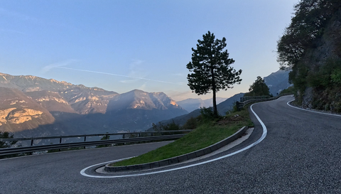





Passo Pian delle Fugazze | 1163 METER | Rovereto Valli del Pasubio
The Passo Pian delle Fugazze, at 1,163 metres, links Rovereto with Valli del Pasubio, although the actual north-westerly ascent probably only really begins at the village of Parocchia. Just before Parocchia, when approaching from Rovereto, the SP219 branches off from the wider SS46 – at a hairpin bend (towards Speccheri). If you take this route, you’ll reach the actual summit and also the official pass sign when approaching from the north-west.
If you stay on the SS46 at Parocchia, you’ll follow the gentler, wider road towards the summit, but you’ll then need to turn right past the car park and restaurant and drive for about 500 metres to reach the summit.
If you’re approaching from the south-east, coming from Valli del Pasubio, you must turn left at the restaurant and car park at the supposed summit. However, the summit sign on this approach is actually situated slightly further down the slope.
Alternative north-west approach from Rovereto:
The SP89 runs on the opposite side of the valley to the SS46. At Asti, it continues onto the SP219 (towards Bruni and Speccheri). The route is slightly longer, and the road is narrower and in poorer condition. However, this provides a direct route to the actual pass summit when coming from Rovereto.
Tips:
Whichever approach you take, the short detour at the junction is well worth it, as it leads, after a short distance, to a car park with a wonderful view.
The climb from or to Rovereto offers plenty of cycling enjoyment and, above all, an extremely beautiful and varied landscape. It runs alongside a wild mountain stream, the Leno di Vallarsa, which has carved its way into a deep valley. You’ll also pass through several picturesque and truly charming little villages, such as Parocchia, which are built along the rocky slopes.
Eremo di San Colombano rock chapel: Just above Rovereto, on the opposite side of the valley, a chapel can be seen. It is built directly against the steep rock faces, which are over 100 metres high, and seems almost to cling to them. It dates back to the 10th century.
Tour tips:
A few kilometres below the summit of the south-eastern ramp, the route to the Passo di Xomo branches off – very inconspicuously – with a 180-degree bend.
Passo di Campogrosso: No longer an alpine pass, but merely a side road, though very interesting and challenging to drive. The road leading there begins in Valli del Pasubio.
| Country | Italien |
| Region | Trentino |
| Coordinates | 45.75747625, 11.16840507 |
| Elevation | 1163 m |
| Max. slope | 10 % |
| Toll road | no |
| Road surface | Asphalt |
| Cul-de-sac | no |
| Length | 39 Km |
| Travel time | Normal |
| Route | Rovereto Valli del Pasubio |
 overcast clouds, 8°C
 Subscribe to Newsletter