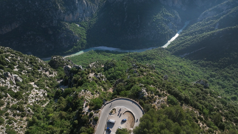
Col d'Illoire – a 180-degree bend with a view down into the 700-metre-deep Verdon Gorge.
1 day ago
Strada dei Cannoni or the Varaita-Maira Ridge Road – off-road driving for connoisseurs.
1 month ago
The ‘Little St Bernard’, 2,188 metres: an Alpine pass set in picturesque countryside and steeped in history.
2 months ago


Buchener Höhe | 1256 METER | Leutasch Telfs
The road over the Buchener Höhe connects the Tyrolean towns of Leutasch and Telfs. The pass summit lies at 1256 metres above sea level.
Passtracks close by:
Seefelder Sattel, Kühtaisattel, Fernpass, Ammersattel, Hahntennjoch
Suggested videos (Passtracks close by)
| Country | Österreich |
| Region | Tirol |
| Coordinates | 47.33815740, 11.12199846 |
| Elevation | 1256 m |
| Max. slope | |
| Toll road | no |
| Road surface | |
| Cul-de-sac | no |
| Length | |
| Travel time | Normal |
| Route | Leutasch Telfs |
 overcast clouds, 16.3°C
Back to hotel