






Würzjoch | 1982 METER | Sankt Martin in Thurn Brixen
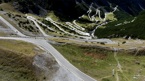
The Würzjoch, at an altitude of 1,982 metres, is an Alpine pass in South Tyrol that links the Gadertal valley with the Eisacktal valley. The pass is flanked to the south by the Peitlerkofel range and to the north by the Lüsener Mountains. The road is narrow and winding in places, but well-maintained on the eastern side. The western side has poorer-quality tarmac and features longer, narrow stretches, some of which offer limited visibility. There are around 40 bends and hairpin bends along the ascent.
Both the eastern and western approaches are split into two sections. To the east, you can travel via St. Martin in Thurn or via Montal, or even via Zwischenwasser (if coming from the Enneberg Valley, from the direction of Furkelsattel). To the west, the route splits towards Klausen and Brixen. The route over the Würzjoch is relatively long at around 45 kilometres (between Sankt Martin in Thurn and Brixen) and takes some time to complete.
Tip: in Sankt Martin in Thurn, right by the ramp, there is a well-preserved castle which houses the Museum Ladin Ciastel de Tor, the Ladin Local History Museum. It’s definitely worth a visit.
Tour tip for the Dolomites circuit: The Würzjoch, with its two sections via Montal and Sankt Martin in Thurn, can be easily incorporated into a motorbike tour around the Sella massif. Although you won’t reach the top of the pass this way, you’ll avoid a few kilometres of traffic (at any time of day) in the narrow valley.
Suggested videos (Passtracks close by)
| Country | Italien |
| Region | Südtirol |
| Coordinates | 46.67500000, 11.81420000 |
| Elevation | 1982 m |
| Max. slope | 15 % |
| Toll road | no |
| Road surface | Asphalt |
| Cul-de-sac | no |
| Length | 45 Km |
| Travel time | Normal to slow |
| Route | Sankt Martin in Thurn Brixen |
 moderate rain, 9.1°C
 Subscribe to Newsletter