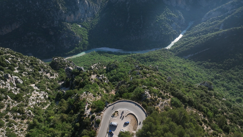
Col d'Illoire – a 180-degree bend with a view down into the 700-metre-deep Verdon Gorge.
1 week ago
Strada dei Cannoni or the Varaita-Maira Ridge Road – off-road driving for connoisseurs.
1 month ago
The ‘Little St Bernard’, 2,188 metres: an Alpine pass set in picturesque countryside and steeped in history.
2 months ago


Region: Graubünden
Berninapass | 2328 METER | Celerina Campocologno
At its highest point, the Bernina Pass connects the Swiss high valley of Engadin in the north with the Puschlavtal and the Italian Veltlintal in the south at an altitude of 2328 metres. The pass road has been kept open all year round since 1965, although it is covered by snow for about eight months of the year. This makes the Bernina Pass one of the highest passes in the Alps to be open all year round.
Passtracks close by:
Forcola di Livigno, Passo di Foscagno, Passo d’Eira, Albulapass, Julierpass
Videos
Suggested videos (Passtracks close by)
| Country | Schweiz |
| Region | Graubünden |
| Coordinates | 46.41072264, 10.02633162 |
| Elevation | 2328 m |
| Max. slope | |
| Toll road | no |
| Road surface | |
| Cul-de-sac | no |
| Length | |
| Travel time | Fast to normal |
| Route | Celerina Campocologno |
 scattered clouds, 5.5°C
Back to hotel