


Predilpass | 1156 METER | Predil | Raibl Bovec
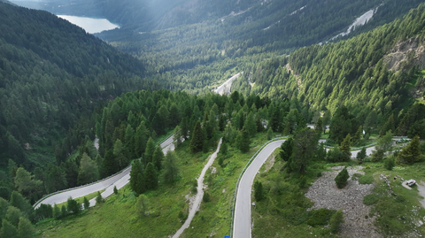
The 21 km long and up to 12 per cent steep road over the Predil Pass (Slovenian: Predel, Italian: Passo di Predil) connects Tarvisio (751 m) in Italy with Bovec (483 m) in Slovenia. 9 km after Tarvisio, you reach Cave del Predil and one kilometre further on, Lago del Predil. The official ascent begins from here. On the Slovenian side, you drive along a mountain road, the Mangart Road, towards Bovec. The road only goes downhill again a few kilometres before Bovec.
Halfway along the road, the ascent to Mangart branches off, a dead-end road up into the Triglav Mountains. From here, you have a magnificent view over the Carnic Alps. The ascent: extremely enjoyable driving, unfortunately somewhat marred by the toll. Tip: get there early, as the number of parking spaces is limited and driving up is prohibited if it is too crowded. Also because the road is narrow in places, almost single-lane.
Just before the border, on the Italian side, is the Predil Bunker, a relic from the First World War. It is worth stopping. A little further along the route are the Predil Fortress (a highlight of the Napoleonic Wars) and the ‘Flitscher Klause’, which was built in the late Middle Ages.
Note: the correct translation for ‘Predel’ is simply ‘pass’. So in the German translation, you drive the Pass-Pass.
Videos
Suggested videos (Passtracks close by)
| Country | Slowenien |
| Region | Slowenien |
| Coordinates | 46.41666670, 13.58333330 |
| Elevation | 1156 m |
| Max. slope | 12 % |
| Toll road | no |
| Road surface | Asphalt |
| Cul-de-sac | no |
| Length | 21 Km |
| Route | Predil | Raibl Bovec |
 overcast clouds, -3.3°C