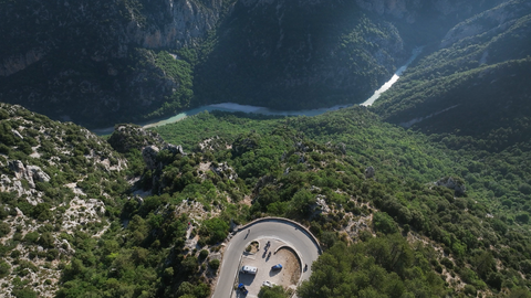
Motomovie Motomovie
Share your passion on motomovie
New Videos
motostories
Back to the video portal
Alpen-Marathon
Alpen-Marathon „7 | 6 | 50“
Alpine Passes Atlas
Alp-passes
Motorcycle tours
Alpine Passes Blog
Sights (POI)
Motohotels
Order Alpine Poster
Order Challenge (Road Map)
Alpen-Marathon Hall of Fame
Alpen-Marathon TV‑Reports
Alpine Marathon News
Der Col de Larche oder Colle della Maddalena, 1991 Meter hoch. Ein Alpenpass mit zwei "Gesichtern".
The Col de Larche, or Colle della Maddalena, 1,991 metres high. An Alpine pass with two “faces”.
2 weeks ago
Colle Fauniera, at an altitude of 2,481 metres, is one of the most spectacular Alpine passes.
2 weeks ago
The Col de Sarenne, 1,999 metres – winding and with little traffic on the eastern slope.
4 weeks ago
Return to overview of the Alpine passtracks Italian French English German
Region: Savoie
Alpine passes atlas

Col de la Madeleine | 1746 METER | Lanslebourg Mont-Cenis Bessans

Text to follow...

Passtracks close by:
Col du Mont Cenis, Col de l’Iseran, Col de Sommeiller, Nivolet-Pass, Assietta-Kammstraße

Suggested videos (Passtracks close by)

Col de l'Iseran | 2,770 metres: the majestic king of Alpine passes. Alpenpaesse-Videos | Alpen-Marathon 2 months ago
Col de l'Iseran | 2770 Meter: seine Majestät unter den Alpenpässen. Alpenpaesse-Videos | Alpen-Marathon 2 months ago
Über 50 Alpenpässe, durch 6 Länder in 7 Tagen – die ultimative Alpenpässe-Tour in 7 Minuten. Alpenpässe-Motorrad-Touren: Alpen-Marathon, die TV-Reportagen 11 months ago
Col du Mont Cenis | Lac du Mont Cenis (2084) – die Alternative zum Alpenpass Col du Galibier. Alpenpaesse-Videos | Alpen-Marathon 1 year ago
Westalpen, Briancon und seine Forts – zwischen Col du Granon und Col de l'Izoard. Alpenpaesse-Videos | Alpen-Marathon 1 year ago
Alpen-Marathon 2022, 7 Tage, 6 Länder, 50 Pässe: Col de l'Iseran – der höchste befahrbare Pass in den Alpen. Impressionen von 2020... Alpenpaesse-Videos | Alpen-Marathon 3 years ago
Country Frankreich
Region Savoie
Coordinates 45.30050294, 6.94797549
Elevation 1746 m
Max. slope
Toll road no
Road surface Asphalt
Cul-de-sac no
Length 13 Km
Travel time Normal
Route Lanslebourg Mont-Cenis Bessans
scattered clouds, 15.2°C scattered clouds, 15.2°C

More Information

AGB Support About us Imprint Privacy

Follow us

Newsletter

Subscribe to our Newsletter to always stay up-to-date. We will not send you spam, promise.

© 2026 motomovie.de
MotomovieSubscribe to Newsletter


Your experience on this site will be improved by allowing cookies.